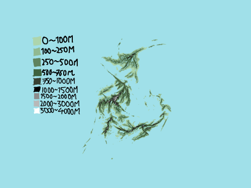
Krukyr
| The Krugen Ecumene ⴽⵃⵜⴳⴴ (Krugen) 瓷國棲居地 (Krugen Chinese) Krukârii Ekuméne (Lhinvi) 瓷器遗产栖居地 (Cho'l) | |
 | |
   | |
| Official Name | The Krugen Ecumene (Krukyrpyuenpizyuz) |
| Common Name | Krukyr |
| Denonym | Krugen |
| Capital | Kyragira |
| Largest City | Kyragira |
| Official Language(s) | Krugen |
| Ethnic Groups | 85,4% Krugens 2,4% Chinese 0,95% Lhinvians 0,65% Chøl |
| Religion | 50,5% Animism 3,3% Abrahamic 38,4% Unaffiliated |
| Government Type | Nonpartisan Meritocratic Democracy |
| Supreme leader | knupp king of crewcar |
| Legislature | Krukseiktez (the (eternal) National Oversight) |
| Continent | Agalon |
| Region | Krugisles |
| Area (km²) | 1.183.001 |
| % Water | ~7,2% |
| Population | 134.217.728 (2025) |
| Density (/km²) | 113,5 |
| Currency | Capshee (Kapsye)(KAP) |
| GDP | $4.994.241.658.880 |
| GDP per capita | $ 37.210 |
| Gini | 19,4% |
| HDI | 0.938 (2024) – very high |
| ISO 3166-1 alpha-2 | KK (.kk) |
| ISO 3166-1 alpha-3 | KRK |
This article uses the Gregorian calendar
Krukyr, officially the Krugen Ecumene, is an island nation situated on The Krugisles off the western coast of Agalon. Being an island nation, it borders the Krugen Sea to the east, the Hafy to the north, (n/a) to the east, and (n/a) to the south. Krukyr has a population of 134.217.728, 96% of which live in urban areas. Kyragira is the capital and largest city with a metropolitan population of 26.064.603, followed by Kyhruks, Zhiruks, and Mimi.
The island of Kelas is claimed by both Kelsia and Krukyr, it is administered by Kelsia from the winter to the summer solstice, and vice versa for Krukyr. It is Krukyr's northernmost point, and is only inhabited during the summer by fishermen.
Etymology
The name Krukyr means inherited from porcelain, from the Krugen words kruk and kyr; meaning porcelain and land of birthright respectively. The name comes from the abundance of Kaolin found in the soil of Ippatnhasya, which was a vital part of the Krugen economy before industrialization. The demonym, Krugen, comes from krug being back-formed from Krukyr as a prefix.
History
Prehistory
Traces of human inhabitation on the Krugisles has been dated back to around 14.000 BC, with prehistoric sites mostly concentrated around modern day Kyragira in the north and Xysu in the south. They were two separate cultures, although they had similar genetic makeup and were in extensive contact; having trading routes running along the eastern coast of Kyhraki. Traces of these Mesolithic populations is seen in the genetic profile of modern Krugen people, with around 40% of Krugen genetic makeup being from these populations.
The neolithic Krugoid peoples started migrating to the islands from the north around 7.200 years ago, having inherited a complex culture that started forming in the River Plains population around 14.500 years ago. They brought agriculture, domesticated animals, extensive seafaring knowledge and their language with them. Due to the sparse population and relatively abundant resources on the islands, they did not conflict with the pre-existing Paleokrugid populations, and eventually merged with them; forming the Proto-Krugen culture. The Unox seafarers started arriving from the Xysu Islands around 6.000 years ago, giving rise to the Forekrugen culture around the Kyhr River, which eventually spread to the rest of the islands, finally forming a unified culture over the course of about half a millennium. Today, around 10% of modern Krugen DNA stems from these seafarers, peaking at 15% in inhabitants of Nizhe.
Forekrugen Era
The Forekrugen Era, also called the Krugen Bronze Age, saw the advent of metal alloy production (bronze), urbanization and written language on the Krugisles. The first evidence of written Krugen date back to around 2700BCE, found around the Kyhr River on Kyhraki, in the form of ideographs used to signal ownership of personal property. This marked the transition from the Proto-Krugen to the Forekrugen culture, which lasted till 1340BCE.
Geography

Krukyr encompasses the majority of the Krugisles, a volcanic island chain characterized by tall mountains, and thousands of lakes and islands. The islands of Kelas and Jarn Kopi are partially and fully administered by Kelsia respectively, and are the only territories of the Krugisles not officially administered by the Government of Krukyr. The Xysu and Nizhe islands have been disputed with Verum, following the coup led by the Kubonicists in the nation.
Most of the Krugen population lives in urban areas around rivers and isthmi, leaving most of the country untouched by human activity. Broken down, around 64% of the archipelago is covered in forests, 12% human activity, 10,6% wetlands / shrublands (depending on the season), 7,2% water, 3% grasslands, 1,7% barren, and 1,5% glacier. The different biomes of Krukyr vary considerably by season; being dryer in the winter and summer, and wetter in the spring due to glacial runoff. The lakes of Ippatnhasya usually freeze over in the winter.